Sea ice extent has decreased by 13% per decade since the 1990s. Traditionally the summer melt season begins in March and ends sometime during September. Now the season is growing longer, and the sea ice minimum is occurring later.
In March 2024, Arctic sea ice extent averaged 14.14 million square kilometers (5.46 million square miles), the lowest in the 47-year satellite record and 150,000 square kilometers (58,000 square miles) below the previous record low March set in 2017. Spring is in the air report from the National Snow and Ice Data Centre (NSIDC). April, 2025.
You can keep up to date with the Arctic sea ice with daily updates from the National Snow and Ice Data Center (NSIDC).
Aaju talks about climate and ice fishing
The Greenland ice sheet
The Greenland ice sheet is the largest body of freshwater ice in the Northern Hemisphere. In the future, this ice sheet will respond to climate change more intensely than other areas of the Arctic.
Major changes in the Greenland ice sheet are to be expected. Higher temperatures mean that the air can hold more moisture and there will be more snowfall in the centre of Greenland raising the height of the ice. This could cause further alterations to atmospheric circulations.
NASA’s Jet Propulsion Laboratory suggests that Greenland has lost a trillion tonnes of ice since 1985 from glacier retreat alone – that’s c.30m tonnes of ice per hour.
Ice melt at the edge of the ice sheet could cause changes to the North Atlantic ocean currents, with knock-on effects on climate systems elsewhere. Greenland holds enough ice to raise global sea levels by 7 metres if it were all to melt.
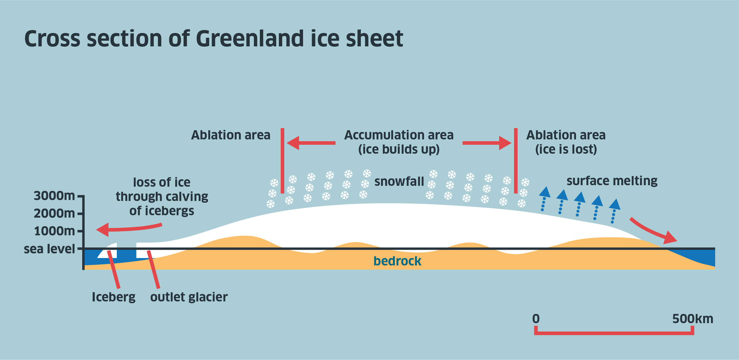
These changes could mean that overall Greenland will lose more ice and snow than it accumulates, with consequences for the global rise of sea level, as the water entering the ocean system will be ‘new’ glacial water which has been locked up on land for thousands of years.
Satellites
For some years now, satellites have been mapping the extent of ice cover and have shown that annual average Arctic sea-ice extent has shrunk by 2.7% per decade since 1978.
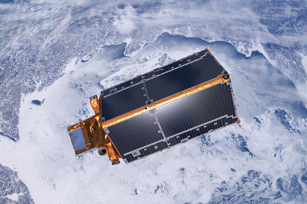
While these observations on ice extent provide invaluable data, this is only part of the picture. To understand fully how climate change is affecting these remote but sensitive regions there remains an urgent need to determine exactly how the thickness of land and sea ice is changing.
NASA has been monitoring the ice in the Arctic since 1979 and as extensive historical data on climate, ice and other information through the National Snow and Ice Data Center. CryoSat 2 was launched by the European Space Agency in April 2010 and is Europe’s first mission to address this. It carries sophisticated technologies using radar to measure changes at the margins of the vast ice sheets that overlay Greenland and Antarctica and marine ice floating in the polar oceans.
By accurately measuring thickness change in both types of ice, CryoSat 2, NASA and other organisations will provide information to complete the picture and lead to a better understanding of the role ice plays in the Earth system.
CryoSat 2’s orbit covers latitudes 88 North and South and much of the data gathered is analysed at the Centre for Polar Observation and Modelling (CPOM).
- Find out more about the results of the Cryosat 2 mission.
- Click here to see the latest findings from the Cryosat2 mission.
- Look at sea ice changes from NASA by clicking here and here.
Satellite advantage?
- What are the advantages and disadvantages of using a satellite rather than researchers in the field?
- What are the potential solutions to the findings from the images shown?
‘Arctic Voice’ discussion
I notice that the weather temperature has changed quite a bit from way back in the middle 50s up to 60s. When we used to hunt and trap whales, it was very cold. It was up to 60 degrees below zero. Today we don’t get that anymore. Once in a while it gets up to -40, but only for a short period of time, and normally around -23 in the winter time… even warmer sometimes. Almost to zero one time I remember in February.
The weather used to be more steady and predictable in the past, and now it is getting a little bit all over the place, and it’s really hard to know what’s coming next. This year was really an exceptional year in terms of rain, for example, because in 36 hours we had our yearly supply of rain, our usual yearly average, in 36 hours or less.
Before, it was possible to catch a seal on the ice through the end of June, but today, it’s already dangerous to walk the ice in May. Even in January, there are thaws, with rain. I can’t recall that happening before. Everywhere, ice cover is melting, which before would have held up year-round. Sometimes, the berries overripen and become soft and bad tasting. There are few cloudberries because the summer is hot.
Viktor Tkachenko, resident of the Chukchi village of Ryrkarpiy
Nature has seriously deteriorated, taken offence at mankind. Spring arrives 2-3 weeks earlier than usual. Spring is harsh, always alternating between rain and frost. The first rain comes in May, but this was not the case before. The first thaw is at the end of April. The rivers break up much earlier than usual, around the 25th of May, when before, it was June 10th-15th. Summer has become intolerably hot. On the ocean, good ice doesn’t form. Before, the ocean ice broke up in the middle of May, but the ice didn’t recede very far. We hunted all summer on the ice.
Grigoriy Rykhtyn, of the village of Vankarem
Climate change impact
- Open the information about the impact of climate change on the Arctic from the WWF.
- Read the information on the impacts as well as potential solutions.
- Summarise this information in a table or mind map.
Frozen ground
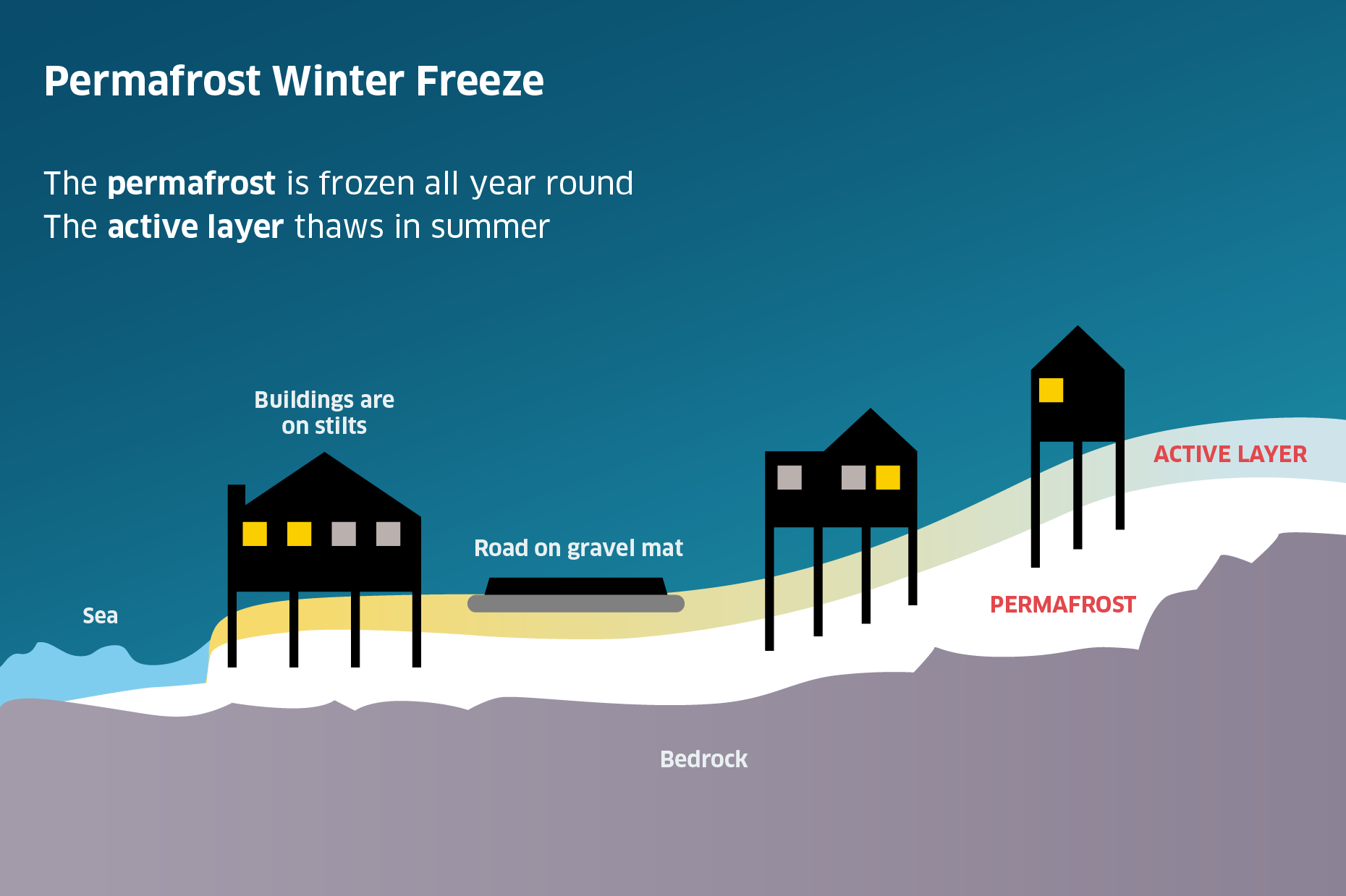
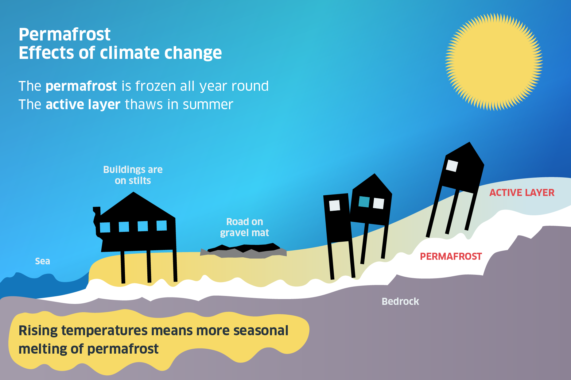
In some places in the Arctic, the ground is not frozen through all year round. Sometimes there is a layer which is permanently frozen to great depths; this is called permafrost, only the top layer called the ‘active layer’ thaws in the summer.
Buildings are built on stilts buried deep in the ground to give them stable foundations. Roads and other flat constructions like airstrips are built on gravel mats for the same reasons.
Moving buildings in the Arctic
Overtime, constant freeze-thawing can damage the foundations which means new ones have to be built. But how do you replace things which are under buildings? by moving the building of course!
Watch the video of the UK Arctic Station in Svalbard being moved for permafrost re-piling.
Warming effects
- What do you think might happen to these areas if the region becomes warmer over time?
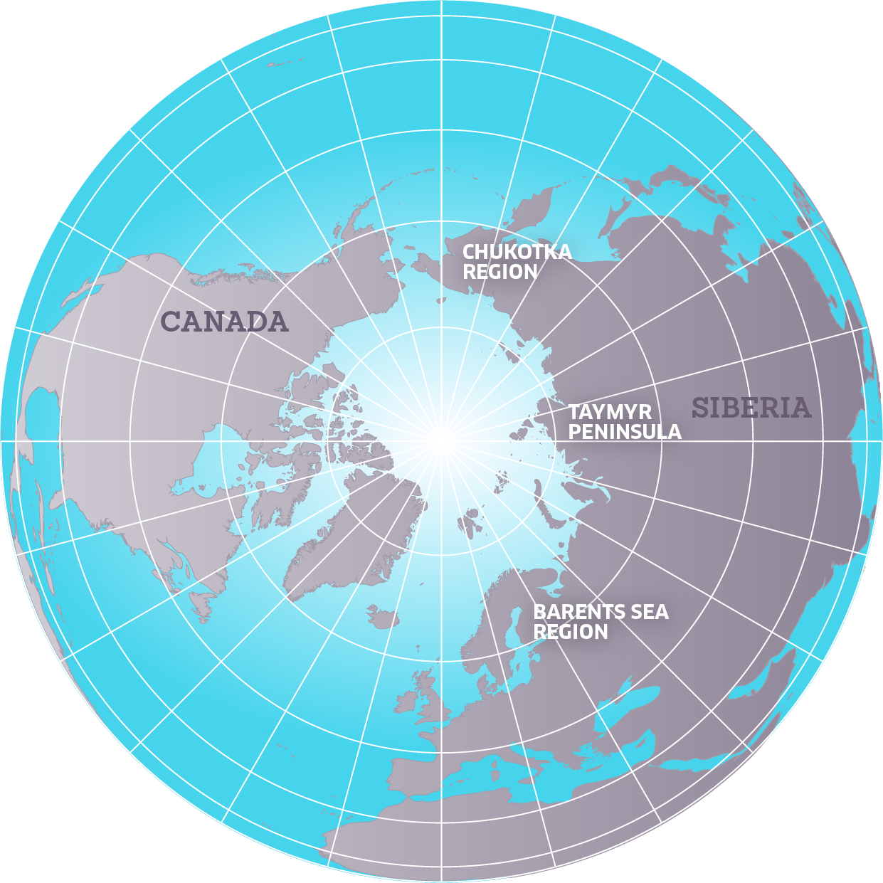
With climate change and raising temperatures more of the active layer thaws in the summer. There is more winter precipitation and the snow blankets the ground keeping it warmer. It is expected that the precipitation will increase by 30% in the Taymyr peninsular of Russia and by 15 – 20% on the Chukotka and Barents Sea regions. As a result buildings’ foundations are weakened. The sea is able to erode the coastline more easily and roads and airstrips become unusable.
Changing lives
- How would these changes affect the lives of the people who live in this region?
Arctic soils contain a lot of carbon in the form of partially decomposed organic matter. As the permafrost layer thaws, this carbon is released into the atmosphere as carbon dioxide and methane, adding still more greenhouse emissions to the atmosphere.
Coastal erosion
- Coastal erosion reveals permafrost at Kaktovik Alaska – This Powerpoint presentation helps you to discover more about the effects of coastal erosion as a result of losing coastal ice.